


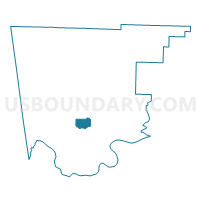
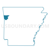
Alma 3, Crawford County, Arkansas
About
Outline

Summary
| Unique Area Identifier | 526286 |
| Name | Alma 3 |
| County | Crawford County |
| State | Arkansas |
| Area (square miles) | 4.36 |
| Land Area (square miles) | 4.35 |
| Water Area (square miles) | 0.01 |
| % of Land Area | 99.78 |
| % of Water Area | 0.22 |
| Latitude of the Internal Point | 35.50121370 |
| Longtitude of the Internal Point | -94.25196620 |
Maps

Graphs
Select a template below for downloading or customizing gragh for Alma 3, Crawford County, Arkansas


Neighbors
Neighoring Voting District (by Name) Neighboring Voting District on the Map
- Alma 2 Voting District, Crawford County, AR
- Alma 4 Voting District, Crawford County, AR
- Oliver Springs Voting District, Crawford County, AR
- Rudy Voting District, Crawford County, AR
- Van Buren 3-3 Voting District, Crawford County, AR
Top 10 Neighboring County Subdivision (by Population) Neighboring County Subdivision on the Map
- Alma township, Crawford County, AR (7,054)
- Oliver Springs township, Crawford County, AR (1,730)
- Rudy township, Crawford County, AR (1,373)